Black Creek Trail

from: Hiking Mississippi - A Guide to Trails and Natural Areas
by Helen McGinnis

Maps from: De Soto National Forest Mississipi Map

comments by Dan Kohn


Black Creek Trail, near Brooklyn, Forrest, and Perry counties (40.8-mile hiking trail). This national recreation trail is exclusively for hikers. Some-times it is close to the banks of Black Creek, with its banks of pure white sand and clear water stained reddish black from natural tannic acid. In the floodway of the creek you will be in the deep shade of magnolias, sweetbay, sweetgum, tulip trees, and oaks. You pass at least one oxbow lake lined with bald cypress and tupelo gum. At other points the route swings away from the creek into rolling hills forested with longleaf and loblolly pine interspersed with steep ravines.

The trail is well blazed with white paint rectangles. Eighty-two bridges, from 6. to 42. long, take you across streamlets and ravines. The steepest terrain along the trail is in the Red Hills near the southeastern end, but there are numerous short and sometimes steep ups and downs along the entire route.

Twenty-one miles of Black Creek, almost entirely federally owned from Moody.s Landing to Fairley Bridge, constitute Mississippi.s only designated national wild and scenic river. Logging is prohibited in a corridor of varying width along the stream to protect the scenery along the creek. Mountain bicycles are prohibited along the entire trail because of this corridor.

The trail was constructed between 1979 and 1982. It was intended to be the first segment of the National Bartram Historical Trail of Mississippi, which would arc its way across southern Mississippi from George County to the Pearl River opposite Bogalusa, Louisiana. The roughly 240-mile route was pro- posed in 1978 as part of the National Trails System, but nothing has been built except the Black Creek Trail.

Access: The trail extends from Big Creek Landing on the northwest to Fairley BridgeLanding at the southeastern end. The Forest Service has built parking areas at both landings and also at two other sites along the trail. One is at the former site of a Civilian Conservation Corps camp south of Brooklyn, and the other is on the west side of Hwy 29, 0.3 mile south of the bridge over Black Creek at Janice Landing.

The parking areas at Big Creek Landing and the CCC camp are close to Brooklyn and other rural communities and are often used by local people for activities other than camping. There are occasional reports of vandalism at these sites.

The trail crosses several other roads. You will have to watch carefully for the modest signs that guide hikers across the roads, and you may have to search for a place to park.

Notes on Major Segments of the Trail. The notes below were made in October 1992, going from west to east. Outside the wilderness area, some of the maturing forests may have been logged, and some of the recently logged areas have grown up into dense tickets of young trees and brush. You may find some changes when you hike the trail.

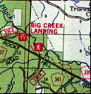
Big Creek Landing to Rockhill-to-Brooklyn Rd. (Rt. 335) (2.9 miles): The trail follows Black Creek closely through mature loblolly pines and southern magnolias.
Rockhill-to-Brooklyn Rd. (Rt. 335) to Point Where Trail Leaves FS 319F-I (6.5 miles): Here the trail turns south away from the creek, taking you through loblolly and longleaf pine forests with hardwood bottoms between Rt. 335 and U.S. Hwy 49. You can explore the site of an abandoned Civilian Conservation Corps camp and find old roads and concrete foundations. This is the least wild section of the trail. It goes around the edges of several recently logged areas, and follows a road (FS 319F- 1) for 0.4 mile.
FS 319F-I to FS 319G (7.0 miles): This segment begins with a delightful walk along an entrenched meandering stream lined with impressively large trees (southern magnolia, beech, water oak, etc.) until you reach the edge of Black Creek. East of the next tributary creek crossing, you walk through the lower edge of a recently logged area. Much of this portion of the trail is on higher ground through pines. Overall, it's a pretty segment.
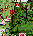
FS 319G to State Hwy 29 (6.8 miles): You start down a grassy lane through pines and descend to a wild section along Black Creek until you reach some recent logging. Then the trail goes through more pines and descends to a flat area with dense understory. A long part of the trail is on split-log "stepping stones." Nonetheless, plan on getting your feet wet, because shallow water may also stand in other portions that lack stepping stones or boardwalks. Next, the longest boardwalk on the trail takes you over a pretty swamp that is not shown on the map.

Finally the trail returns to the creek. Near this point, perhaps on the sharp bend of Black Creek, Joseph Mimm had a ferry in the early 1800s for travelers on the long-abandoned Old Federal Road. It went from Fort Stoddert on the Tombigbee River in Alabama west to the John Ford house in Marion County and on to Natchez. Andrew Jackson and his army camped here on the night of November 25, 1814, on their way to the Battle of New Orleans. Between here and Hwy 29 you will cross and recross a recent low-standard logging access road.
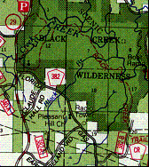
State Hwy 29 Parking Lot to Hwy 29 Bridge over Beaverdam Creek (2.7 miles): Here the trail enters the Black Creek Wilderness. It follows the west side of Beaverdam Creek through dense woods, skirting the edges of deep, flat-bottomed ravines studded with bald cypress. The creek itself is in a trench. You see it only twice, and it is difficult to get down to the stream.

Notes from hike on Feb 13, 1998:

About two minutes in from the parking lot, I got lost at one of the first places you can see the creek. The trail makes a right diagonal into the woods instead of going strait as expected.

About a half hour in, you come to a .T. in the trail by a rotting log, the trail goes right! (Note that hiking towards the parking lot, watch for this turn since it is easly missed. If you continue on strait you will come to a dead end a feel LOST . go back if this happends and you will probably find the trail)

About 40 mins in, you come to an area were there is one blaze across a runnoff reviene. DO NOT CROSS RUNNOFF REVIEN, continue off to the right and you will see a blaze shortly. This spot always costs me a few minutes to figure out.

Trail comes out on road . cross bridge. Trail re-enters woods on the same side of the road.
Hwy 29 Bridge over Beaverdam Creek to Spur Trail from Andrews Chapel on New York Rd (Rt- 382) (0.4 mile): The trail leaves the Wilderness to cross Beaverdam Creek on the highway bridge and reenters it on the other side. Several cars can park off the highway on the southwest side of the bridge. The trail leads through hilly pine woods, joining the unmarked access trail from Andrews Chapel.

Notes from hike on Feb 13, 1998:

About 45 min to an hour in there is a campsite with access to water (although it is Beaver Creek . not a spring). Very nice campsite!

Never saw access trail from Andrews Chapel!?!


Spur trail from Andrews Chapel on New York Rd. to FS 382B (7.7 miles): If you don't feel secure leaving your car along Hwy 29, you can park near the wooden sign reading "Black Creek Wilderness" at the east side of Andrews Chapel. An unmarked but well-worn trail begins near the sign and leads to the Black Creek Trail, which has white paint blazes.

The Black Creek Trail descends from the pine-covered hills and follows the east side of Beaverdam Creek. This is a beautiful stream, the largest you en-counter on the trail apart from Black Creek itself. It's generally in a deep, nar-row trench overhung by large trees. You will see much more of the stream on this side than you will on the west side, and you can get down to the creek easily in some spots.

Eventually you reach Black Creek. There's an excellent campsite on a high sandbar overlooking the confluence of Black and Beaverdam creeks. The route continues along the creek through mature forests in very deep shade to Mills Creek. Here you will find another excellent campsite in mature pines about 500' off the trail on the west side of the confluence with Black Creek. After crossing this rather large stream, the trail turns south and follows an old road to a gas pipe corridor at the eastern edge of the wilderness area.

This is the wildest part of the trail and also the most scenic.
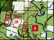
FS 382B to FS 318B-1 (4.3 miles): The trail descends to Black Creek, where you'll find a good campsite or lunch spot with an obvious trail leading to a sandbar favored by canoeists. Then the trail turns back and climbs into the rugged Red Hills. The route goes up and down ridgelines and crosses ravines on picturesque bridges over flowing streams. Interestingly, the hills don't seem particularly red except on recently scraped roads.
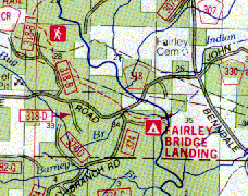
FS 3188-1 to Fairley Bridge Landing (2.S miles): The route gradually leaves the Red Hills (each little ravine is less well pronounced) and then crosses a flat area with longleaf pine and very dense understory. The section between FS 3 1 8 and the end of the trail is pretty, with lots of rhododendron and a tree with a huge burl. There is no water along this section except where FS 374 crosses Bug Branch.

Car Shuttles: You can start your hike at either end of the trail or at a road crossing. If you have only a single car in your party and no one to meet you at another road crossing, you can turn around and retrace your steps. If you don't want to do so, you can arrange with Black Creek Canoe Rental in Brooklyn to let you off where you want to start. The livery will take your car to where you want to end your trip (Black Creek Canoe Rental, PO. Box 414, Brooklyn, MS 39425; 601-582-8817). Call in advance to make arrangements and for up-to-date information on the level of Black Creek.

Backpacking Notes: Plan on taking at least four days to hike the entire 40.8 miles of the trail. Five days are better for most parties. If you plan on taking six days, you will have time for a layover day along Black Creek.

Some of the nicest campsites are on sandbars along Black Creek. The trail tends to approach the edge of the creek closely on the outside of bends, where the current undercuts the bank to create steep drops to the creek. It usually leaves the creek on the inside of bends, where you are most likely to find gentle terrain and sandbars. You may want to leave the trail to look for these sites.

You should have no trouble finding water for camping along the trail away from Black Creek. When I hiked the trail it had rained only once in the last month, but most of the streams marked as intermittent on the topographic map were flowing, as were some not marked on the map at all.

Combined Canoe/Backpack Trip: It's about the same distance from Big Creek Landing to Fairley Bridge landing (41 miles) by canoe or on the Black Creek Trail. You can plan a round trip, going downstream by canoe and upstream by the trail, by hiding your canoe and canoe-related equipment out of sight of roads and the stream. To lessen the possibility of losing your canoe, chain it to a tree.

Generally, it will take you less time to cover the distance by canoe than on foot. Black Creek Canoe Rental suggests allotting the following times for canoeing the creek: Big Creek Landing to Old Brooklyn Bridge (old Hwys 49, 3 16), 5 hours; Old Brooklyn Bridge to Janice Landing, 8.5 hours; Janice Landing to Fairley Bridge Landing, 5.5 hours. Plan on spending three whole days on the creek in addition to the five or six days on the trail to make the complete circuit from Big Creek Landing to Fairley Bridge Landing and back.

Facilities: The Forest Service has provided five boat landings for float trips along Black Creek. Starting at the northwest end, they are: Big Creek, Moody's, Janice, Cypress Creek, and Fairley Bridge. Moody's Landing is only a picnic site. The other four are good base camps for day trips. They are popular for camping and may be filled to capacity in the spring. Fairley Bridge Landing has two tables and chemical toilets. Big Creek has only one table and no privies.

The camping area near Cypress Creek Landing was improved in 1992 and has new tables, gravel tent pads, drinking water, and chemical toilets but no RV hookups. A resident campground host closes the gate to the camping area at10:00 Pm. It's one of the few Forest Service campgrounds I've seen in the last decade that has been improved without converting it to a fee-area RV camp-ground. (Cypress Creek is on the opposite side of Black Creek from the Black Creek Trail, and the only way to get across is by boat or by swimming not ad-visable when the creek is high.)

Maps: The Forest Service's map of the entire DeSoto National Forest is adequate for hiking and canoeing Black Creek, but the Service has also issued a topographic map printed on water-resistant paper for Black Creek hikers and canoeists. Unfortunately, mileages are not given for the trail.