

| Miles from Springer | Features | Elevation |
|---|---|---|
| 273.7 | U.S. 25 & 70, N.C. 209 (1,326') Hot Springs, N.C. 28743 | 1326 |
| 275.1 | Lovers Leap Rock (1,820') | 1820 |
| 277 | Pump Gap (2,130') | 2130 |
| 278.6 | Campsite (2,490') | 2490 |


| Miles from Springer | Features | Elevation |
|---|---|---|
| 278.6 | Campsite (2,490') | 2490 |
| 279.6 | U.S. 25 & 70 overpass, Tanyard Gap (2,278') | 2278 |
| 281.9 | Rich Mountain Fire Tower Side Trail (3,600') | 3600 |
| 283 | USFS 467, Hurricane Gap (2,900') | 2900 |
| 284.7 | Spring Mountain Shelter (3,300') ?14.2mS; 8.6mN | 3300 |
| 286.2 | Spring (3,190") | 3190 |
| 288.4 | N.C. 208, Tenn. 70, Allen Gap, Paint Creek (2,234') | 2234 |
| 290 | Log Cabin Drive (2,560') | 2560 |
| 293.3 | Little Laurel Shelter (3,300') ?8.6mS; 6.8mN | 3300 |


| Miles from Springer | Features | Elevation |
|---|---|---|
| 294.6 | Bald Mountain Road, Camp Creek Bald (4,750') | 4750 |
| 296.3 | Spring, creek (4,390')?blue?blaze trails both sides of A.T. | 4390 |
| 296.4 | White Rock Cliffs (4,450') | 4450 |
| 296.6 | Blackstack Cliffs (4,420') | 4420 |
| 297.6 | Big Firescald Knob (4,360') | 4360 |
| 300.1 | Jerry Cabin Shelter (4,150') ?6.8mS; 6.3mN | 4150 |

| Miles from Springer | Features | Elevation |
|---|---|---|
| 300.1 | Jerry Cabin Shelter (4,150') ?6.8mS; 6.3mN | 4150 |
| 302 | Big Butt (4,750') | 4750 |
| 303.3 | Spring (4,480') | 4480 |
| 303.6 | Shelton Graves (4,490') | 4490 |
| 306.4 | Flint Mountain Shelter (3,570') ?6.3mS; 8.9mN | 3570 |

| Miles from Springer | Features | Elevation |
|---|---|---|
| 307.3 | Campsite (3,400') | 3400 |
| 309.1 | N.C. 212, Devil Fork Gap (3,100') | 3100 |
| 309.6 | Rector Laurel Road (2,960')?several stream crossings on A.T. north of road | 2960 |
| 312.4 | Frozen Knob (4,579') | 4579 |
| 313 | Big Flat (4,160') | 4160 |
| 314 | Rice Gap (3,800') | 3800 |
| 315.2 | Hogback Ridge Shelter (4,255') ?8.9mS; 10.2mN | 4255 |


| Miles from Springer | Features | Elevation |
|---|---|---|
| 315.2 | Hogback Ridge Shelter (4,255') ?8.9mS; 10.2mN | 4255 |
| 315.8 | High Rock (4,460') | 4460 |
| 317.6 | Flag Pond Road, U.S. 23, I-26, Sams Gap (3,800') | 3800 |
| 318.3 | Springs (4,000') | 4000 |
| 319.9 | Street Gap Road, Street Gap (4,100') | 4100 |
| 321.3 | Low Gap (4,300')?spring | 4300 |
| 323.3 | Spring (4,850') | 4850 |
| 324.1 | Big Bald (5,516') | 5516 |
| 324.4 | Big Stamp (5,300') | 5300 |
| 325.3 | Bald Mountain Shelter (5,100') ?10.2mS; 10.6mN | 5100 |


| Miles from Springer | Features | Elevation |
|---|---|---|
| 325.7 | Campsite (4,890') | 4890 |
| 326.7 | Little Bald (5,220')?wooded summit | 5220 |
| 328.7 | Whistling Gap (3,650') | 3650 |
| 329 | Trail to High Rocks (4,100') | 4100 |
| 330.5 | Campsite (3,490') | 3490 |
| 331 | U.S. 19W, Spivey Gap (3,200') | 3200 |
| 331.6 | Oglesby Branch (3,800') | 3800 |
| 335.7 | Spring (3,300')?water for No Business Knob Shelter | 3300 |
| 335.9 | No Business Knob Shelter (3,180') ?10.6mS; 10.5mN | 3180 |
| 338.3 | Temple Hill Gap (2,850') | 2850 |
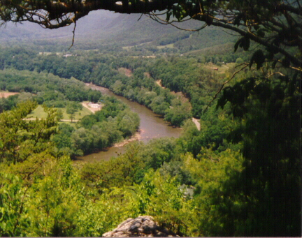
| 342.2 | River Road (1,700') Chestoa Bridge, Nolichucky RiverErwin, Tenn. 37650 | 1700 |
 |  |  |