PA Hike #10 - Shippensburg Rd to Birch Run Shelter to Toms Run Shelter to Shippensburg Rd
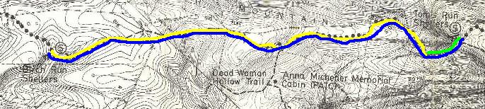
[Leg 1 - Yellow, Leg 2 - Blue, Leg 3 - Green]
Arendtsville-Shippensburg Rd
Mileage: 1064.3
April 1, 1994
I should know better than hike, or try to,
on April Fools Day...well this time the joke was on me.
While driving to the AT, I turned onto what I thought was
a road (it had a name and everything) but it ended up
that it was used as a snowmobile trail. They packed the
snow down so much...it formed into ice (2 inches thick).
Well even in 4 wheel drive I couldn't get out. I don't
know if you could call it "Trail Magic" but a good
Samaritan stopped and helped me out.
Well finally I got
to the Trail and hiked from Shippensburg Road to Birch
Run Shelter. Then I turned around and hiked to Tom's Run
Shelter, then back to the car (Section 13 aprox mileage
12 miles). Nice day for a hike, but with all the snow
melt the AT cold have been a brook. [NOTE: On this hike I
used a map produced by the PACT and found it much easier
to follow it than the KTA maps. Color makes all the
difference! Just don't believe all the "roads" exist or
are passable!) Did run into 2 other hikers and,
unfortunately, 3 mountain bike riders. I mean... can't
these guys read the signs that say "Foot Traffic Only"!
Overall a nice day and one of the easier hikes, probably
the easiest, I have had on the AT!